Saturday, October 31, 2015

Sheafman & Castle Crag Loop

I’ve wanted to do a loop up sheafman canyon of E sheafman peak, W sheafman peak and castle crag for a number of years.  I finally got around to it last weekend and it did not disappoint. 
castle crag from W sheafman
I was surprised to find the road already gated down at the winter trailhead but a fairly painless 35minutes of road running and switchback cutting put me at the summer TH.  I ran the bulk of the 4 miles to the second creek crossing, before backtracking a few hundred feet and leaving the trail, ascending E sheafman peak via the prominent S facing slide path slightly W of the summit. 
ascent route up E sheafman.  next time, descent with skis..
I boulder hopped along the ridge proper all the way to W sheafman, taking the time to investigate skiable passages N down into fred burr creek (2 moderate passages and a few skinny steep couloirs).  Another long stretch of boulder hopping down the W ridge and a short climb put me at aichele lake for a water refill as I admired the striking E face of castle crag.  I’ve heard the obvious dihedral goes at 11-. 
couloir N to fred burr 
S face pt. 8469 up fred burr creek - i'll visit you someday with skis
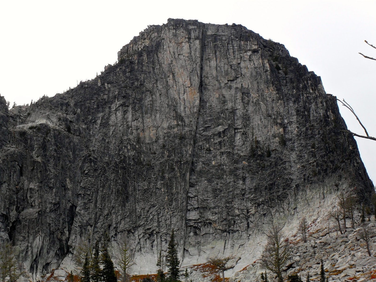
E face castle crag
I ascended castle crag via the standard SE ridge route (class 2+) before taking a direct line up the final 100ft summit fin at exposed 4th class with a few low 5th moves.  I lingered on the summit for a few minutes, eating and soaking in the incredible view.  I had heard castle crag to have one of the best summit views in the entire bitterroot and now having seen it, I certainly agree. 
final 100ft of castle crag's SE ridge - bypass on L and wrap around to summit at class 2+
or climb R side of this fin directly to summit at exposed class 4/low 5th
looking down the N couloir
I took a small detour on the way down to check out the N couloir slightly W of the summit for future reference before descending the SE ridge and dropping down to knack lake for water and to find the summer trail.  An enjoyable 6.5mi run out the well-maintained trail put me at the summer TH and soon thereafter at my truck.

Stats:  approx. 20mi/6400vert/class 2+ (except optional final 100’ castle crag) in 8:10 car-car from winter TH at moderate pace
Approx. splits from summer TH:  2 hrs E sheafman, 3 hrs W sheafman, 4hrs aichele lake, 4:50 castle crag, 5:50 knaack lake, 7:10 summer TH

Rose: vast view from atop castle crag
Thorn: locked gate at winter TH (however the route to/from the summer TH was pretty easy)
Bud: returning for a long ski tour of castle crag, a run down to fred burr and the prominent slide path off E sheafman pt (many variations possible)

Saturday, October 24, 2015

Rattlesnake traverse

With our indian summer continuing to stretch into mid-october, I was able to get out for yet another gorgeous fall day in the mountains.  With some school exams the following week, I needed something close to town and reasonably short to allow sufficient study time as well.  The rattlesnake traverse fit the bill perfectly – super close to town, short and easy bike shuttle and reasonably short time commitment. 
the route, from stuart peak
I’ve done a mosquito to sanders to murphy to point six loop in the spring on skis but never the full traverse w/ stuart so I was excited about the route.  Not wanting to endure a very chilly bike ride that morning, I stashed a bike at snowbowl and drove down to the ravine TH, figuring the ride would be more enjoyable in the afternoon sun.  I felt slow and groggy the first couple of miles headed up to stuart peak but just plodded along at a casual pace, reaching the top in about 2:15, where I chatted with a few folks before setting out for mosquito (they were surprised to hear I was headed all the way to snowbowl, but I informed them that mileage wise, stuart is actually already half way from the ravine TH to snowbowl).
one of many nice ski lines between stuart and mosquito
I bumped into a solo backpacker along the way but otherwise the stretch to mosquito was uneventful.  I took my time descending the NW ridge, stopping to scope the entrance to each of the couloirs that drop down to glacier lake (I’ve skied 2 of them this past spring but am excited to return someday to ski them all in a day – 5 prominent ones appear to go clean).  I re-joined the trail for a short stretch before reaching the saddle and continuing up the broad S ridge of sanders peak. 
sanders (R) and murphy (L) from mosquito
first of many couloirs on mosquito's N face
Despite the slow travel, I decided to stick to the ridge proper between sanders and murphy, which served up some decent and some not-so-decent scrambling, including a short but stellar exposed section of low 5th class terrain.  It would certainly be faster and likely more enjoyable to bypass a good portion of this ridgeline on the south (and keep the difficulty at class 3 or below).  It was nice however to get eyes on a few prominent ski lines that drop N off this ridge to upper finley lake for future reference.
looking W to murphy from west sanders pt.
from murphy, a look back to sanders peak
I reached the summit of murphy nearly 2 hours since sanders (slow!), and was nearly out of water.  The next stretch of ridgeline to point six was fun to see without snow for my first time and nice easy terrain in comparison to the sanders-murphy ridgeline.  I descended snowbowl via high roller to the beargrass highway to lower paradise.  Once at the bike, I was disappointed in myself in not having also stashed water, but a quick and thirsty ride had me down the road and back to the truck, amazed at how close to town this worthwhile wilderness loop resides. 

Approx. splits:  2:15 stuart, 3:45 sanders, 5:30 murphy, 7:20 bike
Stats:  approx. 23mi/7k vert in 7:20 car-bike at casual/moderate pace

Rose: beautiful day, not flaring up my knee
Thorn: slow travel and a lot of loose rock on the sanders to murphy ridge line
Bud: linkup of all the N couloirs on mosquito peak

Friday, October 16, 2015

Southern Madison Range

I spent an enjoyable fall weekend chasing Brian and Jeffrey around the Lee Metcalf Wilderness.  Brian had devised the routes and did most of the routefinding so Jeffrey and I were mainly just along for the ride.  I’m accustomed to studying topos and occasionally google earth ahead of time so it felt a little weird to be out with such little knowledge of the day’s routes but I grew to enjoy the surprises that my naivety allowed.     
a look back at the monument ridge line
Saturday was spent doing a big loop of the skyline ridge from sage creek, off highway 191.  The initial runnable miles up and through monument meadows served a nice warmup as we continued S to monument mt, snowslide mt. and beyond.  We dropped down to an unnamed lake for water before heading up the N ridge of redstreak peak.  On top and feeling good, we decided to stash packs and do a quick out-and-back to white peak before trending W out the skyline ridge.
redstreak peak
skyline ridge
you can see where redstreak gets its name
nearing sage peak
There was some enjoyable 3rd class scrambling on the ridge but it was predominately boulder hopping and technical running.  The ridge went quickly and upon reaching sage peak, we sat and refueled for a few minutes before beginning our descent to sage creek.  My IT band flared up on the sustained downhill and forced me to walk a lot of it but we eventually found ourselves below treeline, and after some minimal bushwhacking, on the trail.  Jeffrey and I were expecting a few miles of trail for the exit so it was a bit to our surprise that we still had 10ish miles back to the car.  We lost the trail a few times at creek crossings but otherwise just slowly pounded out the miles.  We were all tired and happy to see the trailhead at the end of the day.  

Stats: approx. 30mi/7k vert/class 3 in 10.5 hrs car-car

Sunday was spent doing a loop through the hilgard basin.  We ran up sentinel creek trail (actually Brian & Jeffrey ran while I walked a lot due to my IT band) until we found ourselves overlooking the hilgard basin shortly before expedition pass.  The plan was to climb echo peak and traverse S to dutchman and hilgard peaks but cold/windy weather, threatening clouds and snow up high on echo peak prompted us just to do a low traverse through the basins instead. 
dutchman(R) and hilgard peaks
It was beautiful running past the numerous lakes in each basin as we worked our way south, before boulder hopping around the E side of hilgard peak.  We then trended SW up to the head of the basin and climbed what would-be an aesthetic couloir under snow (but was instead a loose pile of rocks) before dropping S down towards avalanche lake.  
headin' up the couloir, all wishing we were skiing instead..
descending to avalanche lake
The 5ish mile egress out the beaver creek trail felt long, with my IT band upset from a 50 mile weekend.  It was well worth it though for the great scenery and company in a new-to-me mountain range. 

Stats: approx. 20mi/5k vert in 9 hrs car-car

Rose: beautiful views from along the skyline ridge
Thorn: continued IT band issues..
Bud: its mid-october so hopefully soon I can stop boulder hopping up & down aesthetic ski routes and start getting out on skis

Sunday, October 4, 2015

Mission Traverse

It started with an e-mail Thursday night – Friday class was cancelled.  Knowing that a storm was supposed to arrive Friday night/Saturday, I scrambled to get things together for a big day in the mountains on Friday.  Fast forward to 5:30 Friday morning and I found myself biking north from the st. mary reservoir, excited to tackle the full mission traverse, just 2 days after the annual july 15 – oct 1 grizzly bear closure around mcdonald peak had ended.

I almost hit a skunk at one point but the (mostly downhill & flat) bike shuttle was otherwise cold, dark and uneventful.  Just past the canal (eastern terminus of red horn lane), I stashed the bike and continued on foot, reaching the upper ashley lakes TH in about an hour, with one strategic switchback cut.  The trail up to the NW ridge of sheepshead was choked with downfall but I’ve become accustomed to a certain amount of this whenever venturing into the Missions.  The upper NW ridge was fun class 3&4 scrambling and it was cool to visit this summit for my first time without skis. 
approaching sheepshead
NW face mcdonald from sheepshead
I descended the E ridge to the mcdonald glacier.  Lacking any traction devices, I had to skirt down/around the glacier and maximize my travel on rock.  I was able to refill water from a glacial melt stream, negating the need to descend to iceflow lake later in the day.  The upper NW face was a bit of a loose slog but I pushed on and reached the summit right at noon, ready for a lunch break.  It was a little intimidating seeing how far in the distance east st. mary (ESM) resided.    
looking S from mcdonald at the route
The descent of the S face was not particularly enjoyable, with most of the rock being too large to comfortably scree-ski yet too small to be stable.  I eventually made it down to the saddle above iceflow lake, and began the climb up N glacier peak, bypassing the lower NW ridge on climber’s left, then up the enjoyable class 4 upper NW ridge to the top.  Thanks to Brian (per usual) for the route beta found here.  I continued SE along the ridge to S glacier peak, marveling at all the incredible ski terrain this mountain range holds.  Although I’ve skied a number of the classic lines in the missions, there is still so much more calling my name. 
iceflow lake
NW ridge of N glacier peak 
garden wall, from S glacier
A quick jaunt from S glacier put me on shoemaker, excited to cross the picturesque garden wall.  I ran most of the garden wall, which is much wider and casual than it appears from afar.  Nearing mountaineer peak, I was tempted to investigate the upper N ridge to the summit but threatening clouds prompted me to take the W face ledge bypass instead.
at 8800', traverse onto W face of mountaineer and up this ramp/ledge and continue easily to summit
There was a sizeable stretch of mellow terrain S of mountaineer that was suitable to running.  Some gendarmes had to be passed south of pt. 9066 above lake of the stars (I went climber’s R around the first and L around the second bigger gendarme).  Soon afterwards came a stretch of nasty looking terrain before the E ridge of lowary.  I bypassed the bulk of it on climber’s R, well below the ridge proper.  With my enthusiasm for route-finding dwindling, I settled for descending one loose, sketchy gully and then climbing the next one to the west.  I’m sure there is a better way through here.  
looking back N from random bump on the ridge before lowary, mcdonald is furthest peak just L of center
E ridge of lowary
ESM summit selfie
With these difficulties behind me, I continued up the E ridge of lowary and then down to vacation pass before slowly making the final climb of the day up the E face of ESM.  I finished my water as I watched the beginning of the sunset and reflected upon what an incredible day it had been (note – I saw 0 people, 0 bears and 2 mountain goats all day).  The trail descent to the reservoir was steep and direct as usual (latter half in the dark) but has been cleared of most everything but the biggest logs since I was last on it this spring.  Thanks to whoever cleared it!

Route:  overgrown trail to NW ridge (class 3/4) sheepshead, down E ridge, across mcdonald glacier, up NW face mcdonald, down S face, upper NW ridge (class 4) of N glacier peak, along ridge to S glacier peak, along garden wall, ledge bypass (class 3) on W face mountaineer, continue S along ridge, bypass tricky gendarmes, up E ridge (class 3) lowary, across vacation pass, up E face ESM, down trail to reservoir

Approx. splits from st mary reservoir:  canal 1:10, upper TH 2:10, mcdonald 6:30, mountaineer 10:20, ESM 13:00, reservoir 14:30

Stats:  approx. 19mi/12k vert/class 4 in 13:20 canal-to-reservoir

Rose: I feel lucky to have snuck in this traverse after the oct 1 date but before snowfall up high complicates the route
Thorn: my piss-poor routefinding around the gendarmes below the E ridge of lowary
Bud: overwhelming amount of great looking ski terrain

Thoughts:  although it is long, this is a stellar outing. I think it could be faster and more enjoyable in late june/early july prior to the july 15th closure with snow glissading opportunities.  with light packs, I think this could be an enjoyable "fast packing" outing with a night spent at/near ice flow lake for those so inclined